
|
Serving Business, Government, OEM, Education and the General Public since 1994
Your source for GPS, OEM GPS sensors, GPS Engine Boards, GPS Tracking,
GPS Antennas, Lidar-Lite, fleet telematics GPS, CB, Amateur and Marine Radios, Radio Scanners,
Fish Finders, Night Vision Optics, and much more!
|
|
|
|
|
|
|
|
Authorized Dealer for Garmin, USGlobalSat
|
|
|
|
|
  Garmin
GPS 18x-5Hz
high sensitivity WASS
enabled OEM GPS sensor for use in machine control,
guidance and agricultural applications that require 5 Hz
position and velocity reports. Small, highly
accurate GPS
receiver. Garmin
GPS 18x-5Hz
high sensitivity WASS
enabled OEM GPS sensor for use in machine control,
guidance and agricultural applications that require 5 Hz
position and velocity reports. Small, highly
accurate GPS
receiver. |
 BU353-S4
USGlobalSat USB GPS receiver highly
sensitive, low power consumption chipset in a ultra
compact form factor. Powered by a SiRF Star IV GPS
chipset. Superior performance in urban canyons,
dense foliage. BU353-S4
USGlobalSat USB GPS receiver highly
sensitive, low power consumption chipset in a ultra
compact form factor. Powered by a SiRF Star IV GPS
chipset. Superior performance in urban canyons,
dense foliage.
|
 GB-580P GPS Bike computer
by USGlobalSat. Slim sports
watch profile. High performance GPS chipset, high
resolution display with e-ink-like qualities under
sunlight, a "Trainer Mode",
GB-580P GPS Bike computer
by USGlobalSat. Slim sports
watch profile. High performance GPS chipset, high
resolution display with e-ink-like qualities under
sunlight, a "Trainer Mode",
|

GPS 16xLVS
Garmin GPS
sensor features a high-sensitivity receiver, integrated antenna and rugged,
waterproof
design that makes it useful for a variety of
OEM applications. |
 eXact Precision NV Scope Kit
2.6 x 44 eXact Precision night vision Scope can be used for multitude of applications including paintball, security surveillance or as a handheld monocular eXact Precision NV Scope Kit
2.6 x 44 eXact Precision night vision Scope can be used for multitude of applications including paintball, security surveillance or as a handheld monocular
|
 Holzberg PX-555U
Compact Professional Portable UHF Two-Way Radio FM
Transceiver. 450 to 470MHz, 4 W, 16-chsnls.
|
 NONM3XG
- Night Owl Optics NexGen 3x Night Vision Scope. 500x Ambient light amplification, powerful Infrared Illumination, NONM3XG
- Night Owl Optics NexGen 3x Night Vision Scope. 500x Ambient light amplification, powerful Infrared Illumination,
|
 |
|
|
|
 Tread Overland Edition (Garmin)
|
|
|
ID # 010-02508-00
Our Price:
$1,299.95
|
DONT ARRIVE AT YOUR
DESTINATION. DISCOVER IT.
Built for every part of the journey, this rugged all-terrain
navigator has the mapping you
need to stay on track and communication technology to stay in
touch while youre out there. |

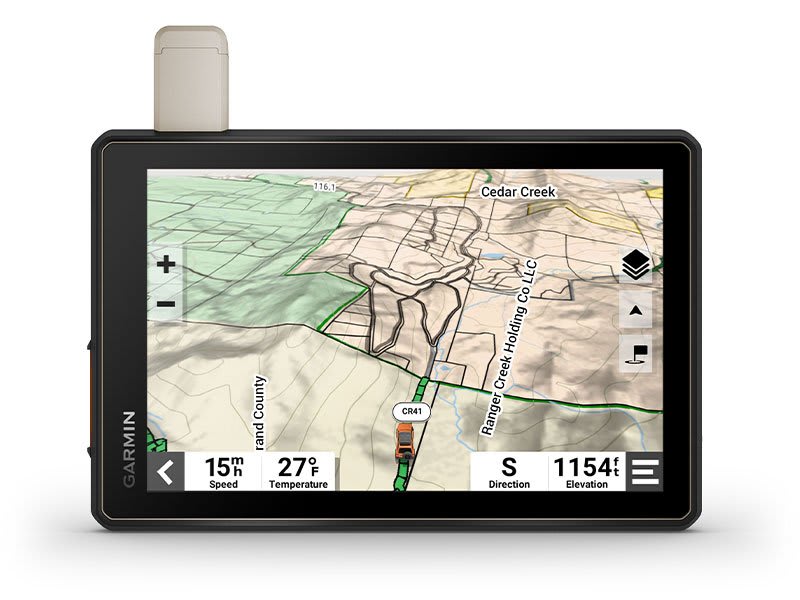
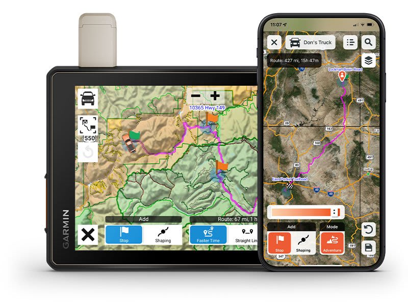
Navigate
unpaved roads and trails by using turn-by-turn trail
navigation1 with
OpenStreetMap (OSM) and USFS Motor Vehicle Use Maps.
|

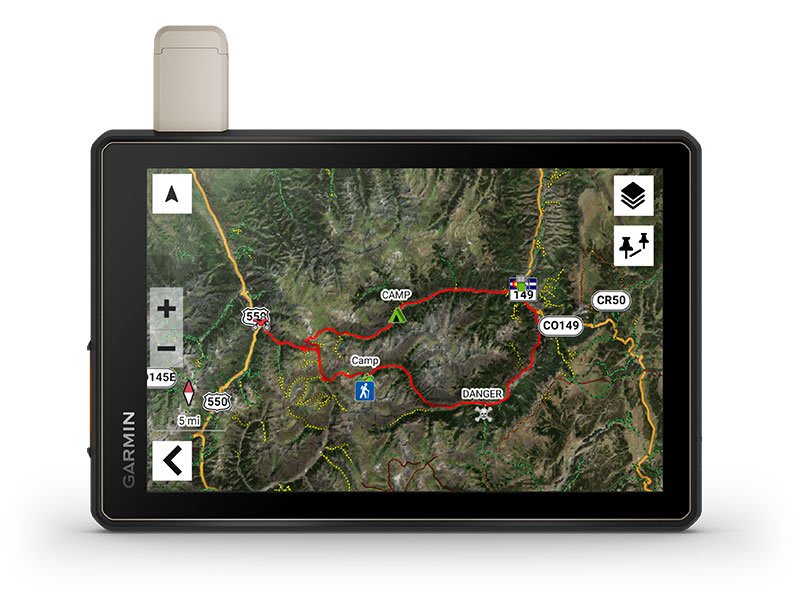
Custom
routing for the size and weight of your rig2 and
preloaded iOverlander points
of interest (POIs) help you find where to set up camp.
|

This
rugged navigator is IP67
weather-resistant and has an 8
ultrabright touchscreen display.
|

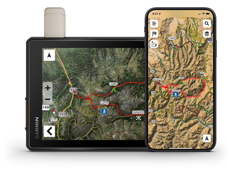
See
vivid aerial views of terrain with downloadable,
subscription-free BirdsEye Satellite Imagery.
|

Use
the Tread® app on
your compatible smartphone to sync data across your various
devices and plan routes.
|

Peace
of mind comes built-in. With an active subscription, you can
use inReach® technology
for global satellite communication.
|
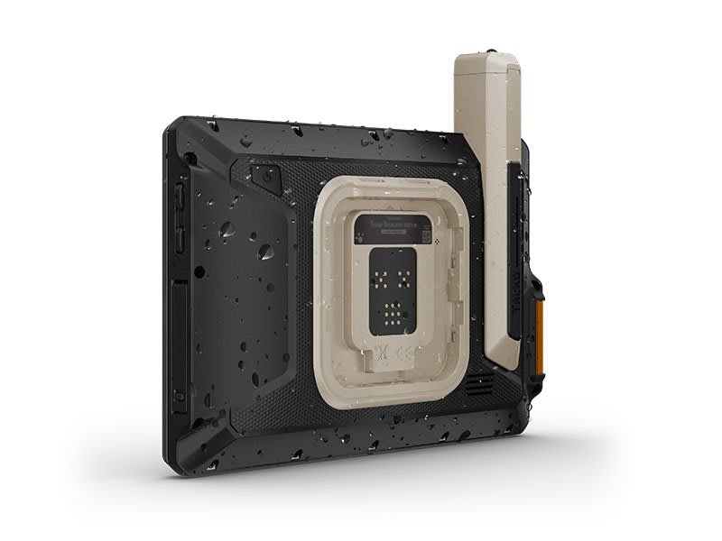
OFF-ROAD
RUGGEDNESS
Purpose-built
for all-terrain use, this Tread device stands up to anything
the elements can throw at it. Its IP67-rated
for water-resistance.
|

HIGH-VISIBILITY
DISPLAY
With
its ultrabright 8 glove-friendly touchscreen, the navigator
is designed for easy viewing in bright sunlight or pitch
dark. It can be mounted in portrait or landscape mode.
|
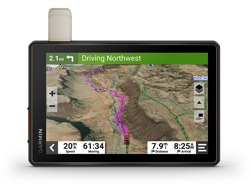
TRAIL
NAVIGATION
Enjoy
turn-by-turn trail navigation for traversing unpaved roads
and trails using adventure roads and trails map content
comprised of OSM and USFS Motor Vehicle Use Maps.
|
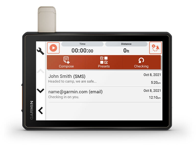
BUILT-IN
INREACH TECHNOLOGY
Built-in
inReach technology offers global satellite communication3,
two-way text messaging, location sharing and interactive
SOS.
|
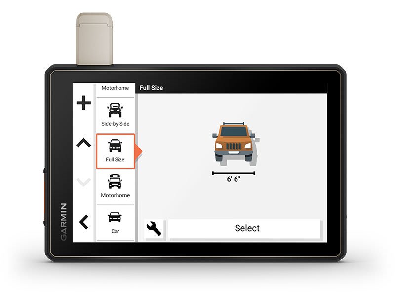
MAPS
ON AND OFF-ROAD
Tread
includes preloaded topographic maps with 3D terrain for
North and South America. It also includes detailed street
maps of North America with custom routing for the size and
weight of your rig2.
|
KNOW
YOUR BOUNDARIES
Access
U.S. public land boundaries for national forests, Bureau of
Land Management (BLM), wilderness areas and more. Also, see
U.S. private land boundaries and landowner information for
parcels greater than 4 acres.
|
SATELLITE
IMAGERY
Enjoy
vivid aerial views when you download high-resolution
BirdsEye Satellite Imagery directly to your device via Wi-Fi® connectivity,
with no annual subscription required.
|
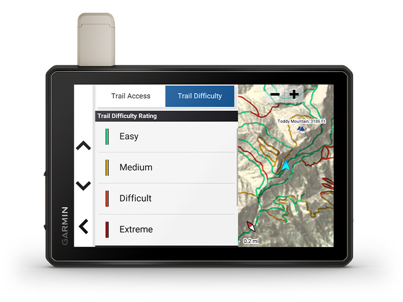
TRAIL
RATINGS
Our
growing trail database now
includes difficulty ratings for off-road riding areas, where
available, across the U.S.
|
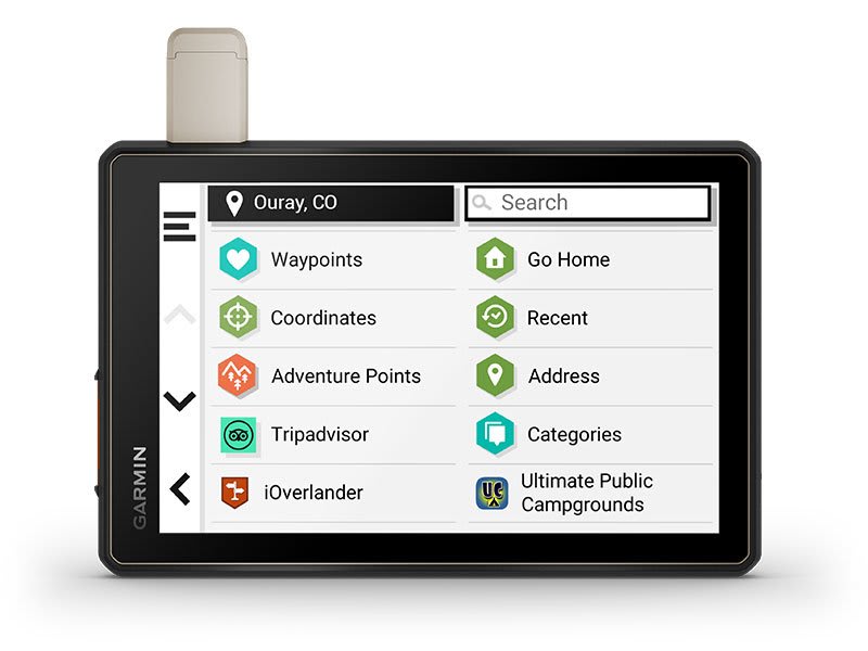
POINTS
OF INTEREST
Tread
comes preloaded with iOverlander points of interest and
Ultimate Public Campgrounds, so you dont need a cell signal
to route to the best-established, wild and dispersed
campsites.
|
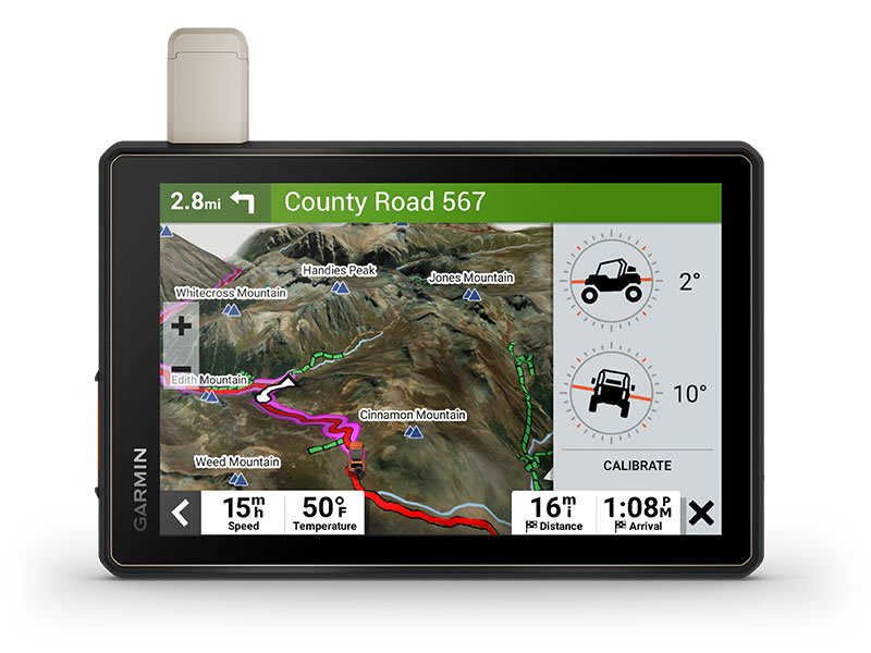
ABC
SENSORS
When
youre headed to tough-terrain, the built-in sensors will
come in handy including an altimeter, barometer, compass
and pitch/roll gauges.
|
SECURE
MOUNT
Use
the included locking magnet-assisted mount to secure the
navigator to your vehicle.
|
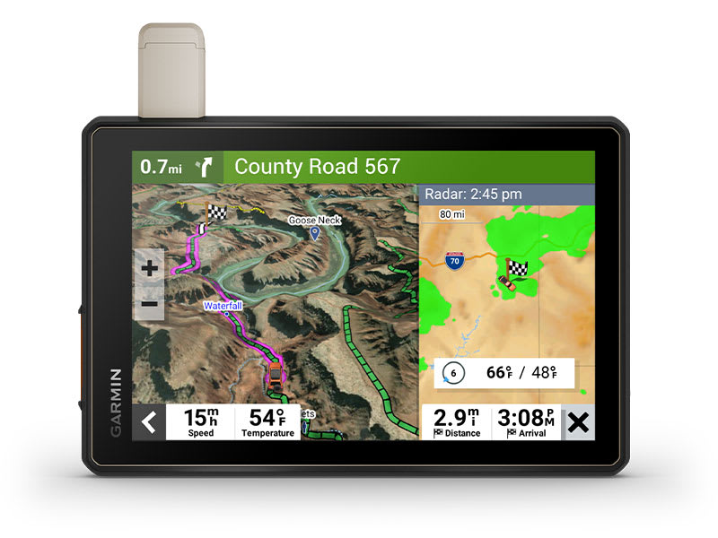
LIVE
WEATHER
Weather
ahead? Pair your Tread device with your compatible
smartphone, and download the Tread app to access live
weather, storm alerts, animated radar and more.
|
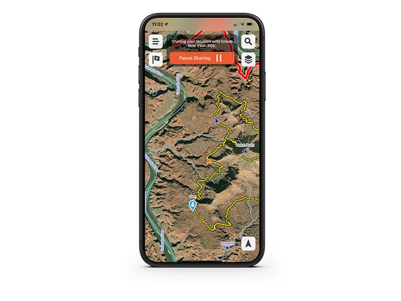
GROUP
RIDE MOBILE
Track
friends from your compatible smartphone or Tread device when
you and your friends use the Tread apps Group Ride Mobile
feature.
|
EASY
ROUTE PLANNER
Use
the Tread app to easily plan routes with the same maps,
vehicle profiles and route preferences that you have on the
Tread device.
|
EASILY
SYNC YOUR DEVICES
Use
the Tread app to sync waypoints, tracks, routes and
collections across all your devices. Easily import and share
GPX files, too.
|
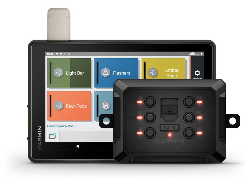
CONTROL
YOUR ACCESSORIES
Pair
Tread with the compatible Garmin
PowerSwitch digital
switch box (sold separately) to enable on-screen control for
your vehicles 12-volt electronics light bars,
differential locks and more.
|
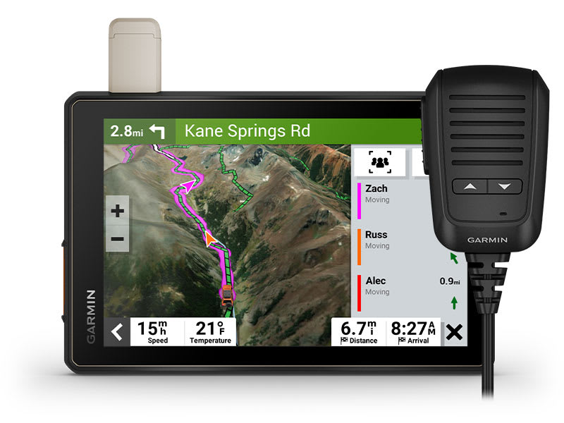
GROUP
RIDE RADIO
Pair
your device with the compatible Group
Ride Radio (sold separately) for
communication and tracking of other Tread-equipped riders in
your group.
|
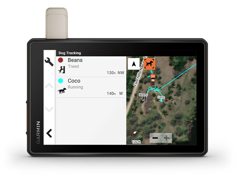
TRACK
YOUR DOG PACK
Wirelessly
pair Tread with select Garmin
GPS dog trackers (sold separately)
to help track and retrieve your sporting dogs in the field.
Youll see markers for each dog within tracking range,
overlaid right on the navigators map screen.
|
1 Limitations
may exist in map data for some road and trail route
suggestions. Always defer to all posted
road signs and conditions during vehicle
operation. The Garmin OpenStreetMap products are
intended
to be used only as a supplementary travel aid.
2 Not
available in all areas. Entering your vehicles profile
characteristics does not guarantee your
vehicles characteristics will be accounted for in
all route suggestions. Always defer to all posted
road signs and road conditions.
3 Active
satellite subscription required for the inReach
features. Some jurisdictions regulate or
prohibit the use of satellite communications devices. It
is the responsibility of the user to know and
follow all applicable laws in the jurisdictions where
the device is intended to be used.
Copyright
© 2022 by iOverlander, LLC. Satellite Imagery © 2021
Maxar Technologies
(date of satellite imagery may vary). Wi-Fi is a
registered trademark of the Wi-Fi Alliance.
Copyright © 2022 Ultimate Campgrounds - All rights
reserved. The Bluetooth word mark and logos
are registered trademarks owned by Bluetooth SIG, Inc.
and any use of such marks by Garmin is under license.
In
the box:
- Tread
- Overland Edition
- Suction
cup mount
- Vehicle
power cable
- Locking
magnet-assisted mount
- USB-C
cable
- Documentation
Specifications
General
|
| DIMENSION |
8.1"W
x 6.7"H x 1.2"D (20.7 x 16.9 x 3.1 cm) |
| DISPLAY
SIZE |
6.8"W
x 4.2"H (10.8 cm x 17.2 mm); 8" diagonal (20.3 cm) |
| DISPLAY
RESOLUTION |
1280
x 800 pixels |
| DISPLAY
TYPE |
multi-touch,
glass, high brightness HD color TFT with white
backlight |
| DUAL-ORIENTATION
DISPLAY |
✔ |
| WEIGHT |
22.8 oz
(646 g)
|
| WATERPROOF |
IPX7 |
| BATTERY
TYPE |
rechargeable
lithium-ion |
| BATTERY
LIFE |
Up
to 6 hours at 50% backlight
Up to 1 hour at 100% backlight
|
| DROP
RATING |
MIL-STD-810 |
| DUST
RATING |
IP6X |
| MAGNETIC
MOUNT |
locking
magnet-assisted mount |
| 1.5"
BALL ADAPTER WITH AMPS PLATE |
✔ |
Maps
& Memory
|
| PRELOADED
STREET MAPS |
✔ |
| HIGH
DEFINITION 3D TERRAIN |
✔ |
| DATA
CARDS |
microSD
card (not included) |
| 3D
TERRAIN |
✔ |
| INTERNAL
STORAGE |
64
GB |
| ABILITY
TO ADD MAPS |
✔ |
| EXTERNAL
MEMORY STORAGE |
yes
(256 GB max microSD card) |
| INCLUDES
MAP UPDATES |
✔ |
| DOWNLOADABLE
SATELLITE IMAGERY |
yes
(BirdsEye) |
Sensors
|
| GPS |
✔ |
| GALILEO |
✔ |
| 10
HZ MULTI-GNSS POSITIONING |
✔ |
| BAROMETRIC
ALTIMETER |
✔ |
| COMPASS |
✔ |
Outdoor
Recreation
|
| POINT-TO-POINT
NAVIGATION |
✔ |
| PRELOADED
TOPOGRAPHICAL MAPS |
✔ |
| PRELOADED
US PUBLIC LAND BOUNDARIES |
✔ |
| PRELOADED
PRIVATE LAND PARCEL MAPS |
yes
(parcels greater than 4 acres) |
| PRELOADED
USFS ROADS AND TRAILS, INCLUDING
MOTOR-VEHICLE-USE-MAPS FOR MOTORCYCLE, ATV, SXS
AND FULL-SIZE 4X4 |
✔ |
| NAVIGATE-A-TRACK
NAVIGATION |
✔ |
| TURN-BY-TURN
TRAIL NAVIGATION |
✔ |
|
Specifications, price and availability are subject to change without notice.
Gross Weight: 3 lbs.
| Sorry, Extended Warranty Options ... are NO Longer Offered |  | | A-RMM31500 | 3-Year Warranty | | $71.99 | | | | | A-RMM51500 | 5-Year Warranty | | $119.99 | | |
| |
 | | A-RMSCP2 | 2-Year Screen Protection Warranty | | $164.31 | | | | | A-RMSCP3 | 3-Year Screen Protection Warranty | | $303.23 | | | | | A-RMSCP5 | 5-Year Screen Protection Warranty | | $550.76 | | |
| |
 | | A-RMEXPT2000 | 1 Year Export Warranty | | $52.99 | | |
| |
|
|
|
|

