
|
Serving Business, Government, OEM, Education and the General Public since 1994
Your source for GPS, OEM GPS sensors, GPS Engine Boards, GPS Tracking,
GPS Antennas, Lidar-Lite, fleet telematics GPS, CB, Amateur and Marine Radios, Radio Scanners,
Fish Finders, Night Vision Optics, and much more!
|
|
|
|
|
|
|
|
Authorized Dealer for Garmin, USGlobalSat
|
|
|
|
|
  Garmin
GPS 18x-5Hz
high sensitivity WASS
enabled OEM GPS sensor for use in machine control,
guidance and agricultural applications that require 5 Hz
position and velocity reports. Small, highly
accurate GPS
receiver. Garmin
GPS 18x-5Hz
high sensitivity WASS
enabled OEM GPS sensor for use in machine control,
guidance and agricultural applications that require 5 Hz
position and velocity reports. Small, highly
accurate GPS
receiver. |
 BU353-S4
USGlobalSat USB GPS receiver highly
sensitive, low power consumption chipset in a ultra
compact form factor. Powered by a SiRF Star IV GPS
chipset. Superior performance in urban canyons,
dense foliage. BU353-S4
USGlobalSat USB GPS receiver highly
sensitive, low power consumption chipset in a ultra
compact form factor. Powered by a SiRF Star IV GPS
chipset. Superior performance in urban canyons,
dense foliage.
|
 GB-580P GPS Bike computer
by USGlobalSat. Slim sports
watch profile. High performance GPS chipset, high
resolution display with e-ink-like qualities under
sunlight, a "Trainer Mode",
GB-580P GPS Bike computer
by USGlobalSat. Slim sports
watch profile. High performance GPS chipset, high
resolution display with e-ink-like qualities under
sunlight, a "Trainer Mode",
|

GPS 16xLVS
Garmin GPS
sensor features a high-sensitivity receiver, integrated antenna and rugged,
waterproof
design that makes it useful for a variety of
OEM applications. |
 eXact Precision NV Scope Kit
2.6 x 44 eXact Precision night vision Scope can be used for multitude of applications including paintball, security surveillance or as a handheld monocular eXact Precision NV Scope Kit
2.6 x 44 eXact Precision night vision Scope can be used for multitude of applications including paintball, security surveillance or as a handheld monocular
|
 Holzberg PX-555U
Compact Professional Portable UHF Two-Way Radio FM
Transceiver. 450 to 470MHz, 4 W, 16-chsnls.
|
 NONM3XG
- Night Owl Optics NexGen 3x Night Vision Scope. 500x Ambient light amplification, powerful Infrared Illumination, NONM3XG
- Night Owl Optics NexGen 3x Night Vision Scope. 500x Ambient light amplification, powerful Infrared Illumination,
|
 |
|
|
|
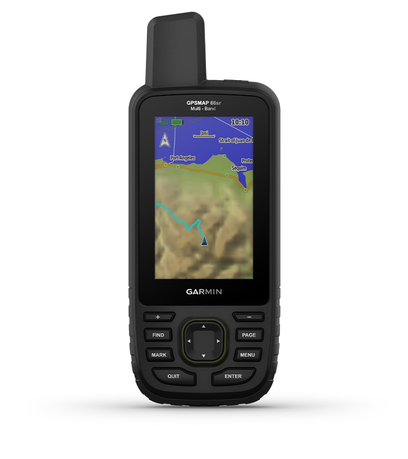
 GPSMAP 66sr (Garmin)
|
|
|
ID # 010-02431-00
Our Price:
$499.95
|
Overview:
NAVIGATE YOUR NEXT ADVENTURE
Whether
youre hiking, hunting, climbing, geocaching, kayaking or mountain
biking, explore more by using this premium, rugged handheld with a 3
color display, preloaded maps and multi-band frequency support providing
you with the best possible positioning technology.  No squinting necessary with this large, sunlight-readable color display.  Multi-band technology and expanded GNSS satellite support guide the way in challenging locations.  Maps as pretty as a picture and just as detailed without a subscription.  See the peaks and valleys clearly with TopoActive maps for the U.S. and Canada.  Having Active Weather is like having your own personal weather forecaster on your journey1.  Explore more with up to 36 hours of battery life in GPS mode and up to 450 hours in Expedition mode.
 EXPANDED GNSS SUPPORTAccess multiple global navigation satellite systems (GPS, GLONASS, GALILEO and QZSS) to track in more challenging environments. 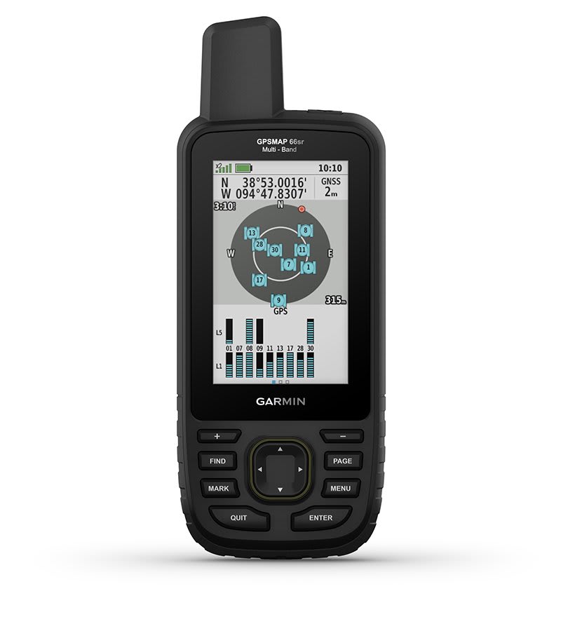 MULTI-BAND FREQUENCY SUPPORTReceive
and utilize multiple frequencies sent by navigation satellites which
enables improved user position accuracy, specifically in areas where
GNSS signals are reflected, weak or typically do not penetrate. Get
superior accuracy using state of the art technology, previously only
available to the military. 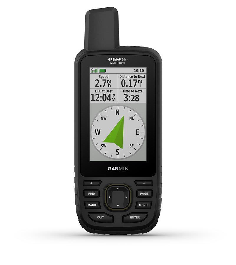 ABC SENSORSNavigate
every trail with ABC sensors, including an altimeter for elevation
data, barometer to monitor weather and 3-axis electronic compass. 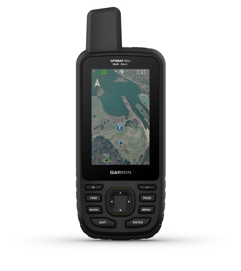 BIRDSEYE SATELLITE IMAGERYDownload
high-resolution photo-realistic maps directly to your device without an
annual subscription. Easily find trails, pick stand locations, find
parking, create waypoints and more. 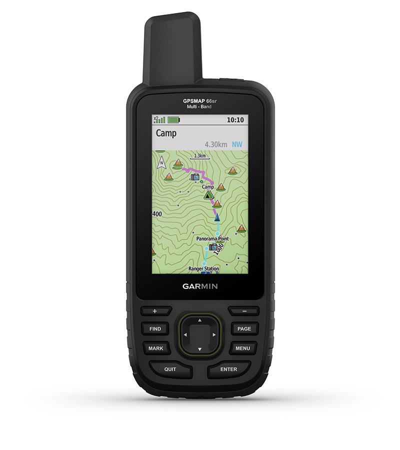 PRELOADED TOPO MAPSPreloaded TopoActive U.S.
and Canada maps show you terrain contours, topographic elevations,
summits, parks, coastlines, rivers, lakes and geographical points. 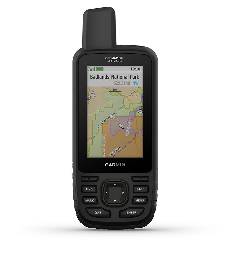 PUBLIC LAND BOUNDARIESOptional
display of federal public land boundaries on topographical maps helps
you know that youre venturing where youre supposed to be. 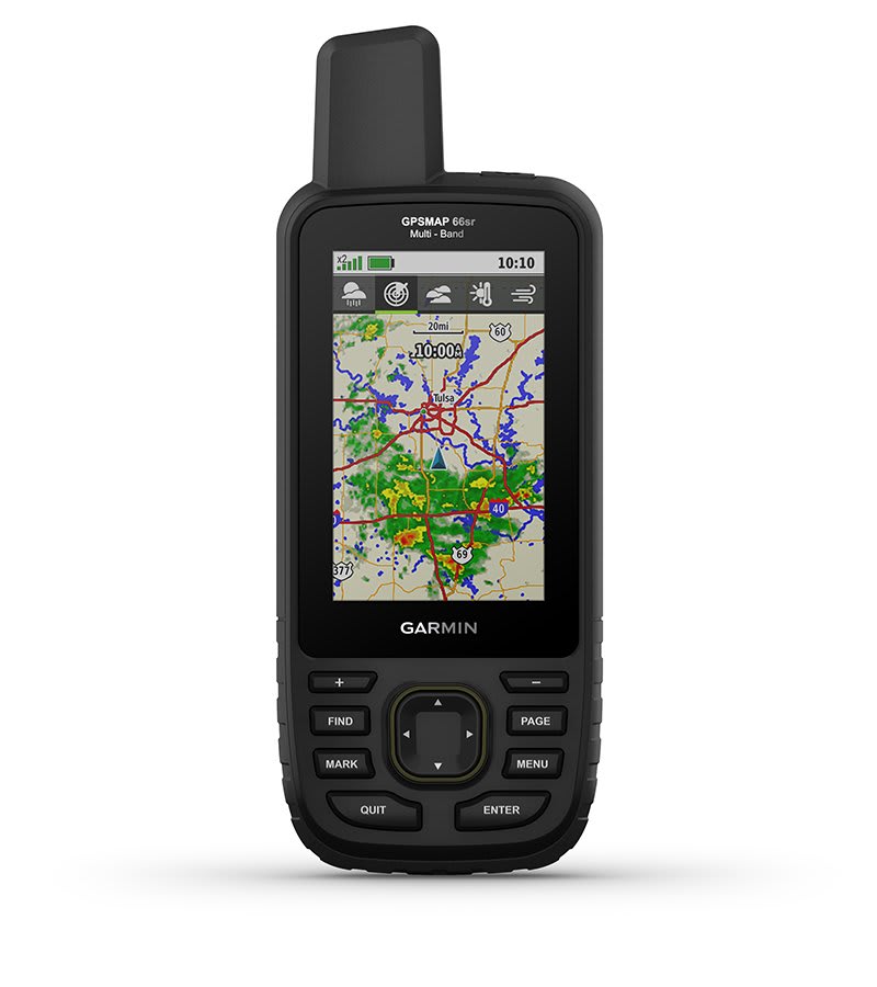 ACTIVE WEATHERWhen paired with your compatible smartphone, you can get real-time forecast information and live weather radar, so youre aware of the surrounding conditions1. 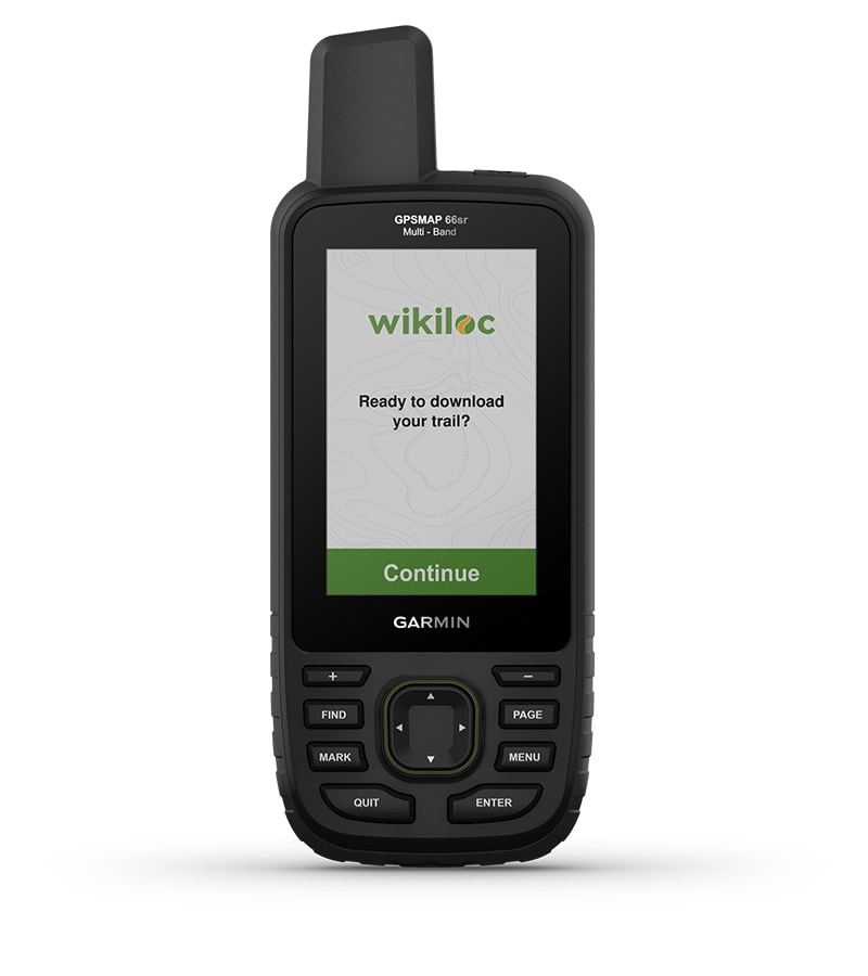 WIKILOC TRAILSThis preloaded app lets you easily download hiking, cycling and other Wikiloc trails shared by outdoor enthusiasts like you. Get a free 60-day Wikiloc Premium trial to try this and other exclusive features. Learn more.
BUILT FOR ADVENTUREThis
handheld is built to military standards for thermal, shock and water
performance (MIL-STD-810), and its even compatible with night vision
goggles. LED FLASHLIGHTThe
GPSMAP 66 series helps you keep gear to a minimum with a built-in LED
flashlight that can be used as a beacon to signal for help. GEOCACHINGGet automatic cache updates from Geocaching Live, including descriptions, logs and hints. When connected via Wi-Fi® technology or to the Garmin Connect app2, each find will upload to your Geocaching.com profile. GARMIN EXPLORE APPPlan, review and sync waypoints, routes and tracks by using the Garmin Explore app2 and website. You can even review completed activities while still in the field. BATTERY LIFEInternal
Lithium-ion rechargeable battery provides up to 36 hours of battery
life in GPS mode and up to 3 weeks in Expedition mode.
1 When paired with your compatible smartphone; see Garmin.com/ble; not available in out-of-coverage areas Wi-Fi is a registered trademark of the Wi-Fi Alliance. In the box:
- GPSMAP 66sr
- USB cable
- Carabiner clip
- Documentation
Specifications:
Physical & Performance
| Display Size | 1.5"W x 2.5"H (3.8 x 6.3 cm); 3" diag (7.6 cm) | | Battery type | Rechargeable, internal lithium-ion | | Display resolution | 240 x 400 pixels | | GPS | Yes | | Dimension | 2.5" x 6.4" x 1.4" (6.2 x 16.3 x 3.5 cm) | | Interface | high speed micro USB and NMEA 0183 compatible | | Waterproof | IPX7 | | Weight | 8.1 oz (230 g) with batteries | | Display Type | transflective color TFT | | Battery life | Up to 36 hours
Up to 450 hours in expedition mode | | High-sensitivity receiver | Yes |
Maps & Navigation| External memory storage | yes (32 GB max microSD card) | | Waypoints/favorites/locations | 10000 | | Preloaded maps | yes (TopoActive; routable) | | Basemap | Yes | | Navigation Routes | 250, 250 points per route; 50 points auto routing | | Navigation Track Log | 20000 points, 250 saved gpx tracks, 300 saved fit activities | | Memory/History | 16 GB (user space varies based on included mapping) | | Ability to add maps | Yes |
Features| Send route selection to MapShare during trip | No | | QZSS | Yes | | BirdsEye | yes (direct to device) | | Send waypoints to MapShare during trip | No | | Active Weather | Yes | | Contacts | No | | Rinex logging | No | | inReach remote widget | Yes | | Pairs with Garmin Connect Mobile | Yes | | Touchscreen | No | | LED beacon flashlight | Yes | | inReach remote compatible | No | | Sun and moon information | Yes | | Virtual keyboard for custom messaging | No | | MapShare compatible with tracking | No | | IRNSS | No | | Geocaching-friendly | yes (Geocache Live) | | Send and receive text messages to other inReach device | No | | GLONASS | Yes | | Send and receive text messages to SMS and email | No | | Frequency band | No | | Displays national, state and local parks, forests, and wilderness areas | Yes | | Smart notifications on handheld | Yes | | Connect IQ (downloadable watch faces, data fields, widgets and apps) | Yes | | Custom maps compatible | yes (500 custom map tiles) | | Compatible with Earthmate | No | | Dog tracking | No | | Connections Wireless Connectivity | yes (Wi-Fi®, BLUETOOTH®, ANT+®) | | LiveTrack | Yes | | Exchange locations with other inReach device | No | | Vibration alert | No | | Map segments | 15000 | | Point-to-point navigation | Yes | | Picture viewer | Yes | | Barometric altimeter | Yes | | Weather | No | | XERO Locations | Yes | | Interactive SOS | No | | VOX (voice activation) | No | | Automatic routing (turn by turn routing on roads) for outdoor activities | Yes | | GPS compass (while moving) | Yes | | Includes detailed hydrographic features (coastlines, lake/river shorelines, wetlands and perennial and seasonal streams) | Yes | | Multi-band frequency support | Yes | | Includes searchable points of interests (parks, campgrounds, scenic lookouts and picnic sites) | Yes | | Hunt/fish calendar | Yes | | Camera | no | | Compass | Yes (tilt-compensated 3-axis) | | Compatible with Garmin Explore app | Yes | | Tracks | 250 | | Galileo | Yes | | Garmin Explore website compatible | Yes | | Area calculation | Yes | | MIL-STD-810 | yes (thermal, shock, water) | | Location reporting (send and receive GPS positions) | No | | VIRB® Remote | Yes |
|
Specifications, price and availability are subject to change without notice.
Gross Weight: 2 lbs.
| Sorry, Extended Warranty Options ... are NO Longer Offered |  | | A-RMM3500 | 3-Year Warranty | | $37.49 | | | | | A-RMM5500 | 5-Year Warranty | | $66.49 | | |
| |
 | | A-RMSCP2 | 2-Year Screen Protection Warranty | | $164.31 | | | | | A-RMSCP3 | 3-Year Screen Protection Warranty | | $303.23 | | | | | A-RMSCP5 | 5-Year Screen Protection Warranty | | $550.76 | | |
| |
 | | A-RMX500 | 1-Year Replacement Warranty | | $49.99 | | |
| |
 | | A-RMEXPT500 | 1 Year Export Warranty | | $37.49 | | |
| |
|
|
|
|

