Overview:
Dedicated GPS Navigator with Driver Awareness
- Easy-to-use,
dedicated GPS navigator with 6.0-inch dual-orientation
display
- Preloaded with
detailed lifetime maps¹ of the U.S. or U.S. and Canada
(depending on the model selected)
- Driver alerts for
increased awareness, including upcoming sharp curves,
school zones, speed changes and more
- Garmin Real
Directions feature guides like a friend, using
landmarks and traffic lights
- Find new and popular
restaurants, shops and more with Foursquare®
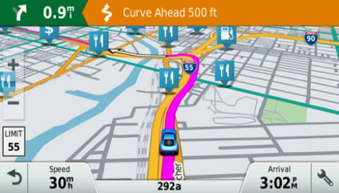
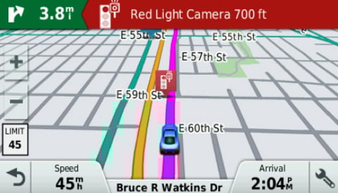
Helpful Driver
Alerts for Your Daily Commute
Garmin Drive 60 GPS
navigator provides driver alerts to encourage safer
driving and increase situational awareness. Warnings
include alerts for sharp curves, speed changes, railroad
crossings and animal crossings. Additionally, Garmin Drive
60 notifies you when driving the wrong way on a one-way
street and sends warnings for nearby school zones. Receive
alerts for nearby red light and speed cameras². For longer
drives, a fatigue warning³ suggests break times and
potential rest areas after hours of driving. The Up Ahead
feature lets you easily see places up ahead and milestones
along your route, without leaving the map view.
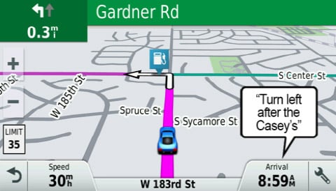
Guidance Using
Recognizable Landmarks
Garmin Drive 60
redefines spoken turn-by-turn directions with Garmin
Real Directions, easy-to-understand driving directions
that guide like a friend, using recognizable landmarks,
buildings and traffic lights (e.g., Turn right after the
red building or Turn left after the QT). Its preloaded
with millions more new and popular places, thanks to
Foursquare.
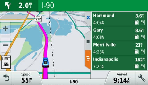
Find Exactly Where
You Need to Go
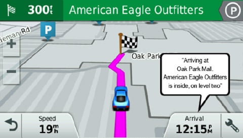
The Direct Access
feature simplifies navigating to select complex
destinations, like airports and shopping malls, by finding
a place within a larger location. Direct Access even
navigates through parking lots to find the entrance
nearest your destination. When navigating to the mall,
Direct Access gives additional location information for
specific retail stores inside. For example, Arriving at
Woodfield Mall. Anthropologie is inside, on the upper
level.
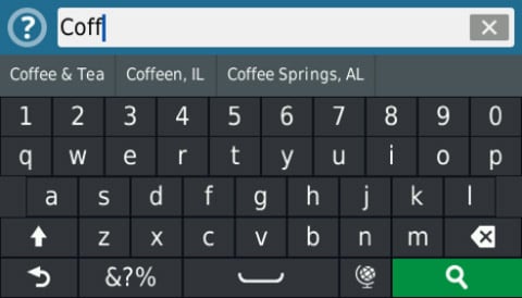
Easier to Search,
Quicker to Find
Garmin Drive 60 has
a search field that makes it easy to find addresses and
millions of points of interest (POIs). Simply enter a
category (like pizza), an entire address (1234 Sycamore
Lane, Anytown, USA) or a proper name (Starbucks), and
Garmin Drive 60 quickly returns your results.
Add a Camera to
Your Drive
For a complete
navigation solution, Garmin Drive 60 pairs with the BC 30
wireless backup camera (sold
separately; professional installation recommended). Once
connected, you can easily see vehicles, pedestrians and
other obstacles right on the Garmin Drive 60 display, as
you move in reverse. When traveling with a baby or
toddler, add Garmin babyCam to your
drive. babyCam is an in-vehicle video baby monitor that
conveniently provides an on demand view of your backseat
passenger, right on your navigation display.
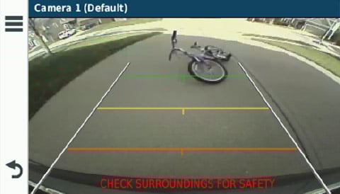 
NOTICE: Some jurisdictions regulate or
prohibit the use of camera devices. It is your
responsibility to know and comply with applicable laws and
rights to privacy related to the use of these devices in
jurisdictions where you plan to use a camera device.
One-stop Device
Management

Use Garmin
Express to keep your Garmin Drive 50 up to
date. Garmin Express makes it easy to update maps and
software, transfer favorites to and from devices and
install free custom vehicles and voices.
¹Lifetime
Maps Terms & Conditions
²Red light and speed camera warnings are not available in
all regions
³The fatigue warning activates after longer periods of
consecutive driving without any long stops along the route
Foursquare® is a
registered trademark of Foursquare Labs, Inc.
 
In
the box:
- Garmin
Drive 60LM
- Preloaded maps of
the U.S. and Canada
- Lifetime maps¹
(indicated by LM after model number on the box)
- Vehicle power cable
- Vehicle suction cup
mount
- USB cable
- Quick start manual
Specifications:
Physical & Performance
|
| Physical dimensions |
6.7"W x 3.7"H x .8"D (17 x 9.4 x 2.1 cm) |
| Display size, WxH |
5.36"W x 2.83"H (13.6 x 7.2 cm); 6.1" diag
(15.4 cm) |
| Display resolution, WxH |
800 x 480 pixels |
| Display type |
WVGA color TFT with white backlight |
| Weight |
8.5 oz (241 g) |
| Battery |
rechargeable lithium-ion |
| Battery life |
up to 1 hour |
| High-sensitivity receiver |
Y
|
Maps & Memory
|
| Preloaded street maps |
Y
|
| Includes lifetime map updates |
Y
|
| nüMaps Guarantee |
Y
|
| Built-in memory |
internal solid state |
| Accepts data cards |
microSD card (not included) |
| Custom POIs (ability to add
additional points of interest) |
Y
|
| Waypoints/favorites/locations |
1000 |
Navigation Features
|
| Speaks street names (e.g. "Turn
right ON ELM STREET in 500 ft.") |
Y
|
| Lane assist (guides to proper
lane for navigation) |
Y
|
| Junction view (displays junction
signs) |
Y
|
| Route avoidance (avoid highways,
tolls etc.) |
Y
|
| Speed limit indicator (displays
speed limit for most major roads in the U.S. and
Europe) |
Y
|
| View upcoming points of interest
along route |
Y
|
Additional
|
| Additional |
- Trip planner:
yes
- Trip log: yes
- Powered magnetic mount: no
- Garmin Real Directions
landmark guidance: yes
- Foursquare POIs: yes
This USB
mass storage device is compatible with Windows® XP
or newer and Mac® OS X 10.4 or later.
|
|


