Share
Star Lite International, LLC - GPS Sensors Serving Business, Government, OEM, Education and the General Public since 1994
Your source for GPS, OEM GPS sensors, GPS Engine Boards, GPS Tracking, GPS Antennas, Lidar-Lite, fleet telematics GPS, CB, Amateur and Marine Radios, Radio Scanners, Fish Finders, Night Vision Optics, and much more!
Search:


You are currently a USA customer. Click on a button below to change countries.

Authorized Dealer for Garmin, USGlobalSat


GPS 18x-5HzGarmin GPS 18x-5Hz high sensitivity WASS enabled OEM GPS sensor for use in machine control, guidance and agricultural applications that require 5 Hz position and velocity reports. Small, highly accurate GPS receiver.
BU353-S4 BU353-S4 USGlobalSat USB GPS receiver highly sensitive, low power consumption chipset in a ultra compact form factor. Powered by a SiRF Star IV GPS chipset. Superior  performance in urban canyons, dense foliage.
GB-580P Cycling computer  GB-580P GPS  Bike computer by USGlobalSat. Slim sports watch profile. High performance GPS chipset, high resolution display with e-ink-like qualities under sunlight, a "Trainer Mode", 
GPS 16XLVS
GPS 16xLVS Garmin GPS sensor features a high-sensitivity receiver, integrated antenna and rugged, waterproof design that makes it useful for a variety of OEM applications.
eXact Precision NV Scope KiteXact Precision NV Scope Kit 2.6 x 44 eXact Precision night vision Scope can be used for multitude of applications including paintball, security surveillance or as a handheld monocular
PX555U Holzberg PX-555U
 Compact Professional Portable UHF Two-Way Radio FM Transceiver. 450 to 470MHz, 4 W, 16-chsnls.
NONM3XGNONM3XG - Night Owl Optics NexGen 3x Night Vision Scope. 500x Ambient light amplification, powerful Infrared Illumination,
Manta 


Astro 320 Bundle
No Longer Available    Astro 320 Bundle (Garmin)
ID # 010-00976-00
  
Overview:

Astro is the premier high-sensitivity GPS-enabled tracking system for sporting dogs. This unique system pinpoints your dog's position and shows you exactly where he is, even when you can't see or hear him. The new Astro 320 handheld GPS device has features that hunters have been asking for like increased range, a simplified user interface and must-have mapping capability.

See Your Dogs' Every Move

The Astro system includes the redesigned Astro 320 and the rugged, orange polyurethane DC 40 transmitter collar. The collar accommodates most e-collar receivers, eliminating the need to put two separate collars on a dog. Plus, Collar Lock creates a 4-digit PIN number that helps prevent others from seeing your dog's whereabouts a useful feature in field trials to ensure that an Astro is used only as a recovery tool when a dog in competition becomes lost.

To get started, just take Astro outdoors and turn on the handheld and transmitter to acquire GPS satellite signals. Then attach the DC 40 to your dog. Now you're ready to turn him loose  no other setup required.

Experience the Improved Astro 320

More intuitive and easier to use, the new Astro 320 takes dog tracking to an entirely new level. The interface streamlines what is displayed by allowing dogs that are outside the current zoom level to have their location notated in the display's margin. The user also can choose the amount of each dog's tracklog displayed, or toggle it off completely, to avoid cluttering the map.

The Astro 320, compatible with any Garmin DC series transmitter, also debuts innovative features like enhanced map drawing capabilities, BirdsEye Satellite Imagery compatibility (subscription required), vibration-based alerts and a 3-axis electronic compass.

Thanks to the redesigned antenna, the maximum range between the Astro 320 and a Garmin tracking collar has been increased by nearly 30 percent up to 9 mi in flat, unobstructed terrain.

Both durable and waterproof, Astro 320 features the legendary toughness that's built to withstand the elements be it dust, dirt, humidity or water, none of which are a match for this essential hunting companion.

Upgrade with Ease

Getting what you need for the hunt is now a little easier. Hunters have the option of purchasing the entire Astro bundle, a stand-alone Astro 320 or as many DC 40 collars as necessary. And if you do get the 320, remember it's compatible with every DC series dog collar.

Get Additional Mapping

With its microSD™ card slot, Astro 320 lets you purchase and load TOPO U.S. 24K maps for land elevation contours or City Navigator NT® map data for turn-by-turn routing on roads (see maps tab for compatible maps). Astro 320 also supports BirdsEye Satellite Imagery (subscription required), that lets you download satellite images to your device and integrate them with your maps. Mapping depicts important nearby geographical features – and lets hunters know, for example, if their dog has crossed a creek or is nearing a dangerous road.

In addition, Astro 320 is compatible with Garmin Custom Maps, free software that transforms paper and electronic maps into downloadable maps for your device.

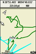
Track Dogs in Dense Cover

As often as every 5 seconds, your dog's DC 40 transmits his position to your handheld, and you can see his current location and a trail of 
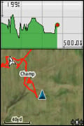
where he's been on the map page of your handheld. Switch over to the Dog Tracker page to view a compass pointing to your dog's location as well as his current status: whether he's running, sitting, on point or treeing quarry. Astro also can sound an alarm to let you know instantly when your dog goes on point.

Each dog's precise distance also can be presented on the map page, and users can choose an option that auto zooms the map so all dogs can be seen on the display at any time. Alternately, dogs that are too far away to fit on the map's current zoom scale can be notated on the display's margin in the direction of the dog's location. The user also can choose the duration that each dog's tracklog is viewed on the display or toggle it off completely for a cleaner display.

Astro boasts a high-sensitivity GPS receiver that can track your dog's position even in the densest cover. You can track up to 10 dogs at one time with Astro, at a distance of up to 9 mi away (depending on terrain). The system transmits information by line-of-sight, so it reaches farthest in flat, open territory.

Count Your Coveys

After you've captured your quarry, mark the exact spot with Astro's Covey Counter, a special waypoint that tells you the exact location, time of day and elevation where you found your prey, as well as the number of birds you flushed and took from that location. Astro lets you save other special waypoints, such as "Truck" and "Lodge," so you can save the location of these places quickly and easily for each hunt. Astro also offers special waypoint icons to represent food plots, tree stands and other hunting-related points.

Plan Your Next Trip

Take charge of your next hunting adventure with BaseCamp, software to view and organize your maps, waypoints, routes, and tracks and send them to your Garmin device. This free trip-planning software displays topgraphic map data in 2-D or 3-D on your computer screen, including contour lines and elevation profiles. It also can transfer an unlimited amount of satellite images when paired with a BirdsEye Satellite Imagery subscription as well as geotag photos, or associate them with specific waypoints.

Due to varying international regulations, this version of the Astro is approved for use only in the U.S. The sale and unlicensed use of the Garmin Astro GPS dog tracking system in any form is presently prohibited by the Canadian government. According to a document published by Industry Canada dated June 2009, the MURS radio frequency used by the Astro will be permitted to be sold and operated on a license-free basis at the end of a 5-year transition period (June 2014). This Industry Canada ruling may be found in its entirety at http://www.ic.gc.ca/eic/site/smt-gst.nsf/eng/sf09543.html. Parties interested in the implementation of this spectrum utilization policy or with questions should contact their local Industry Canada office.

WAAS enabled Geocaching ready SiRF

Features:
Customizable Dog Display

Customizable Dog Display

Tracking man's best friend has never been so easy. WIth the 320, you can choose to see a combination of your dog's name, direction, distance and status so you can see everything without leaving your map.

Stay Up-to-date

Stay Up-to-date

Your dog covers some serious ground, but you don't need to. Stay focused on where you're going, while keeping up-to-date on your dog, even when he or she has gone off screen.

Share Dogs

Share Dogs

Need to share your dog with a pal? No worry. Wirelessly send, receive or transfer a dog's name, ID and update rate between units. You can track up to 10 dogs at a time, at a distance of up to 9 mi away (depending on the terrain).

Activity Logging

Activity Logging

Keep track of what you did, when you did it, with Astro's improved calendar. It automatically and conveniently links all of your marked points and logged tracks to the day of the hunt for later review, or bragging rights.

Dashboards

Dashboards

Bring more functionality to your device with more dashboards in more places. View your elevation plot, coordinates, compass arrow and more on any page, at any time.

Improved Interface

Improved Interface

Bigger and bolder, the 320 uses larger icons and text so you can find what you're looking for faster. Plus, the interface streamlines what is displayed by allowing dogs that are outside the current zoom level to have their location notated in the display’s margin.

The Big Dog Just Got Better

  • Uses HotFix® and a high sensitivity receiver to acquire satellites
  • Offers an improved base map with Digital Elevation Model
  • Offers improved mapping support with access to TOPO U.S. 24K, BirdsEye Satellite Imagery, Garmin Custom Maps, City Navigator NT®, BlueChart® g2 and more (sold separately)
  • Allows you to adjust your dog's track length
  • Zooms in (and out) quickly to find your dog
  • Tracks 10,000 points of information per dog, ensuring your records are accurate no matter how long you are out
  • Uses a universally accepted GPX file format to store all of your data
  • Includes a keypad lock to stop accidental key presses
  • Allows you to switch profiles - hunting, recreational, automotive, marine, geocaching, fitness, etc. - quickly so you won't miss a beat once you're done hunting
  • Debuts innovative features like enhanced map drawing capabilities, vibration-based alerts and a 3-axis electronic compass
  • Features legendary toughness that's built to withstand the elements be it dust, dirt, humidity or water
  • Marks your exact spot with Covey Counter, a special waypoint that tells you the exact location, time of day and elevation where you found your prey
  • Saves other "special" waypoints, such as "Truck" and "Lodge" as well as waypoint icons to represent food plots, tree stands and other hunting-related points

What's in the Box:

Astro Bundle

  • Astro 320 handheld
  • DC 40 wireless transmitter collar
  • Extended range antenna
  • Carrying case
  • Belt clip
  • AC adapter for DC 40
  • Manuals

Specifications:

Physical & Performance:

Unit dimensions, WxHxD: 2.4" x 6.3" x 1.4" (6.1 x 16.0 x 3.6 cm)
Display size, WxH: 1.43" x 2.15" (3.6 x 5.5 cm); 2.6" diag (6.6 cm)
Display resolution, WxH: 160 x 240 pixels
Display type: transflective, 65-K color TFT
Weight: 9.2 oz (260.1 g) with batteries
Battery: 2 AA batteries (not included); NiMH or Lithium recommended
Battery life: up to 20 hours
Waterproof: yes (IPX7)
Floats: no
High-sensitivity receiver: yes
Interface: USB

Maps & Memory:

Basemap: yes
Preloaded maps: no
Ability to add maps: yes
Built-in memory: 1.7 GB
Accepts data cards: microSD card (not included)
Waypoints/favorites/locations: 2000
Routes: 200
Track log: 10,000 points, 200 saved tracks

Features & Benefits:

Automatic routing (turn by turn routing on roads): yes (with optional mapping for detailed roads)
Electronic compass: yes (tilt-compensated, 3-axis)
Touchscreen: no
Barometric altimeter: yes
Camera: no
Geocaching-friendly: yes (paperless)
Custom maps compatible: yes
Photo navigation (navigate to geotagged photos): yes
Outdoor GPS games: no
Hunt/fish calendar: yes
Sun and moon information: yes
Tide tables: yes
Area calculation: yes
Custom POIs (ability to add additional points of interest): yes
Unit-to-unit transfer (shares data wirelessly with similar units): yes
Picture viewer: no
Garmin Connect compatible (online community where you analyze, categorize and share data): yes
Additional:

Range: DC-40: 9 miles (line of sight)

Frequency band: MURS

Vibration mode: yes

Tracks up to 10 dogs simultaneously


Specifications, price and availability are subject to change without notice.
Gross Weight: 4  lbs.


Sorry, Extended Warranty Options ... are NO Longer Offered
A-RMM37503-Year Warranty$137.02
A-RMM57505-Year Warranty$151.59

Has Accessories ...List PriceOur Price  
Accessory Kits
010-10851-10Automotive Navigation kit$49.99$36.95
010-11343-00NiMH battery kit$24.95
Mounts
010-11602-00Auto Friction Mount$39.99$37.95
010-11031-00Marine Mount for Colorado$29.99$25.95
010-11023-00Bike/Cart Mount$9.95
Cables
010-10851-12Vehicle Power Cable$28.00$24.95
010-10723-01USB cable$14.99$13.95
Cases and Covers
010-10117-02Carrying Case$12.69$11.93
Lanyards - Straps - Holsters and Clips
010-11733-00Quick Release Lanyard$14.99$13.99
010-11734-20Belt Clip$9.95
010-11022-10Belt Clip$9.99$7.19
VHF Antennas
010-10931-00Magnetic mount antenna$39.00$34.95
010-10856-00Antenna, Astro (2-pack)$20.00$18.95
010-11141-00Portable Long Range Antenna$69.99$64.95
010-10856-30Extended Range Antenna$26.99$25.95
Dog Tracking Collar
010-11484-00DC 40 GPS Dog Tracking Collar TransmitterNo Longer Available.
Click for possible alternatives and accessories
Other
Maps
010-11314-50TOPO U.S. 24K West DVDNo Longer Available.
Click for possible alternatives and accessories
010-11315-50TOPO U.S. 24K Southwest DVD$129.99$99.95
010-10469-00TOPO Canada DVDNo Longer Available.
Click for possible alternatives and accessories
010-C1086-00TOPO Canada microSD/SD card$129.99$109.95
010-C1009-00TOPO Canada - East$86.14$74.95
010-C1010-00TOPO Canada - Northwest$86.14$74.95
010-C1011-00TOPO Canada - Nunavut$86.14$74.95
010-C1012-00TOPO Canada - West$86.14$74.95
010-C1013-00TOPO Canada - Central$86.14$74.95
010-11555-00TOPO Spain$219.99
010-C1053-00TOPO IsraelNo Longer Available.
Click for possible alternatives and accessories
010-11551-00City Navigator North America$77.95
010-10755-00microSD preprogrammed card, City SelectNT - Mexico$49.99$44.95
010-11752-00City Navigator South America$98.95
010-10680-50MicroSD Card - Europe$97.95
010-10691-02microSD preprogrammed card, City NavigatorNT - Spain & Portugal$99.99$81.95
010-10691-00microSD preprogrammed card, City NavigatorNT - UK & Ireland$99.99$81.95
010-10691-03microSD preprogrammed card, City Navigator - Nordics$99.99$81.95
010-10691-05microSD preprogrammed card, City NavigatorNT - Italy & Greece$99.99$81.95
010-10759-00MicroSD Preprogrammed Card - Brazil$99.99$89.95
010-11595-00City Navigator Southern Africa micro SD / SD card$99.99$96.69
010-11550-00City Navigator Middle East & Northern Africa NT$119.99$115.95
010-11248-00City Navigator® Russia$118.95
010-11432-00City Navigator India$99.99$89.95
010-11652-00City Navigator Southeast Asia NT$99.99$95.95
010-11548-00City Navigator Egypt$97.95
010-11565-00City Navigator Morocco$97.95
010-10215-04Trip and Waypoint Manager$29.99$27.10


Website by IntelliGineering.com