|
Serving Business, Government, OEM, Education and the General Public since 1994
Your source for GPS, OEM GPS sensors, GPS Engine Boards, GPS Tracking,
GPS Antennas, Lidar-Lite, fleet telematics GPS, CB, Amateur and Marine Radios, Radio Scanners,
Fish Finders, Night Vision Optics, and much more!
|
|
|
|
|
|
|
|
Authorized Dealer for Garmin, USGlobalSat
|
|
|
|
|
  Garmin
GPS 18x-5Hz
high sensitivity WASS
enabled OEM GPS sensor for use in machine control,
guidance and agricultural applications that require 5 Hz
position and velocity reports. Small, highly
accurate GPS
receiver. Garmin
GPS 18x-5Hz
high sensitivity WASS
enabled OEM GPS sensor for use in machine control,
guidance and agricultural applications that require 5 Hz
position and velocity reports. Small, highly
accurate GPS
receiver. |
 BU353-S4
USGlobalSat USB GPS receiver highly
sensitive, low power consumption chipset in a ultra
compact form factor. Powered by a SiRF Star IV GPS
chipset. Superior performance in urban canyons,
dense foliage. BU353-S4
USGlobalSat USB GPS receiver highly
sensitive, low power consumption chipset in a ultra
compact form factor. Powered by a SiRF Star IV GPS
chipset. Superior performance in urban canyons,
dense foliage.
|
 GB-580P GPS Bike computer
by USGlobalSat. Slim sports
watch profile. High performance GPS chipset, high
resolution display with e-ink-like qualities under
sunlight, a "Trainer Mode",
GB-580P GPS Bike computer
by USGlobalSat. Slim sports
watch profile. High performance GPS chipset, high
resolution display with e-ink-like qualities under
sunlight, a "Trainer Mode",
|

GPS 16xLVS
Garmin GPS
sensor features a high-sensitivity receiver, integrated antenna and rugged,
waterproof
design that makes it useful for a variety of
OEM applications. |
 eXact Precision NV Scope Kit
2.6 x 44 eXact Precision night vision Scope can be used for multitude of applications including paintball, security surveillance or as a handheld monocular eXact Precision NV Scope Kit
2.6 x 44 eXact Precision night vision Scope can be used for multitude of applications including paintball, security surveillance or as a handheld monocular
|
 Holzberg PX-555U
Compact Professional Portable UHF Two-Way Radio FM
Transceiver. 450 to 470MHz, 4 W, 16-chsnls.
|
 NONM3XG
- Night Owl Optics NexGen 3x Night Vision Scope. 500x Ambient light amplification, powerful Infrared Illumination, NONM3XG
- Night Owl Optics NexGen 3x Night Vision Scope. 500x Ambient light amplification, powerful Infrared Illumination,
|
 |
|
|
|
|
No Longer Available
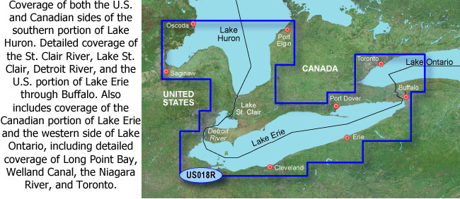
VUS018R - Lake Erie - Lake St. Clair (Garmin)
|
|
|
ID # 010-C0719-00
|
Overview:
Get a Fresh Perspective
Get a fresh perspective when you take to the water with BlueChart®
g2 Vision®. With BlueChart g2 Vision data, you'll get detailed
marine cartography that provides convenient viewing of nautical content
and other premium features. BlueChart g2 Vision allows you to see your
vessel's precise, on-chart position in relation to navaids, coastal
features, anchorages, obstructions, waterways, restricted areas and
more. You will also have access to detailed mapping capabilities that
include Safety Shading¹, Fishing Charts¹, smooth data
transition between zoom levels, harmonious transition across chart
borders, and reduction of chart discontinuities. Premium features
include 3-D perspective above and below the waterline, Auto Guidance,
high-resolution imagery, and real picture aerial photos of ports,
harbors, marinas, waterways, landmarks and other points of interest.
It's the most realistic mapping display Garmin has ever offered.
Features:
- Realistic navigation features showing
everything from shaded depth contours and coastlines to spot soundings,
navaids, port plans, wrecks, obstructions, intertidal zones, restricted
areas, IALA symbols and more.
- Smooth display presentation including
seamless transitioning between zoom levels and more continuity across
chart boundaries.
- Safety shading¹ allows user to enable
contour shading for all depth contours shallower than user-defined safe
depth.
- Fishing charts¹ to help scope out
bottom contours and depth soundings with less visual clutter on the
display.
- High-resolution satellite imagery, when
overlaid on the chart, provides the mariner with a realistic view of
the land and water for unparalleled situational awareness.
- Aerial reference photography provides
"real world" photos of ports, harbors, marinas, waterways, navigation
landmarks and other points of interest, offering the mariner another
powerful tool for navigating unfamiliar waters.
- MarinerEye view 3-D perspective provides
a bird's eye view from behind the boat showing the chart information
for a quick, reliable and easy position fix.
- FishEye view 3-D perspective provides an
underwater view that visually represents the sea floor according to the
chart's information.
- Auto Guidance technology searches chart
data to suggest the best passage to a destination. Includes tides,
currents, marine services, coastal roads and points of interest.
- Compatible with HomePort software that
lets you use BlueChart data to conveniently plan and organize routes
from your computer before your trip.
Map Coverage:
|
Specifications, price and availability are subject to change without notice.
Gross Weight: 1 lbs.
|
|
|
|